For most of us in the upper Midwest, the end of February is usually riddled with snow storms and lingering winter cold.
February 28th, 2017 was anything but a typical Winter day.
I never truly intended to chase on this day, to be honest the best threat for tornadoes looked to be way south and I was fighting a cold and fever that just made for a miserable time.
After a late night/early morning review of weather models though, it became apparent we needed to chase in northern Illinois.
A few things that stuck out were a boundary would lay across the region and the Energy Helicity was pretty much maxed out, as well as models showing a rotating supercell across the area that afternoon.
Earlier on Tuesday morning I awoke to severe thunderstorms across southern Wisconsin, something that has not happened since 1999. These storms contained some very large hail, just a prelude of the strength of this system.
Soon after the new severe weather forecast from the Storm Prediction Center came out and tornado probabilities were raised a bit north and everything seemed to be coming together nicely for a severe weather outbreak.
Jason and I met up and got on the road about 1:00pm with a target of Mendota Illinois, the line of thinking was it was between I-88 and I-80 and that seemed to be the best possible place to set up in the middle.
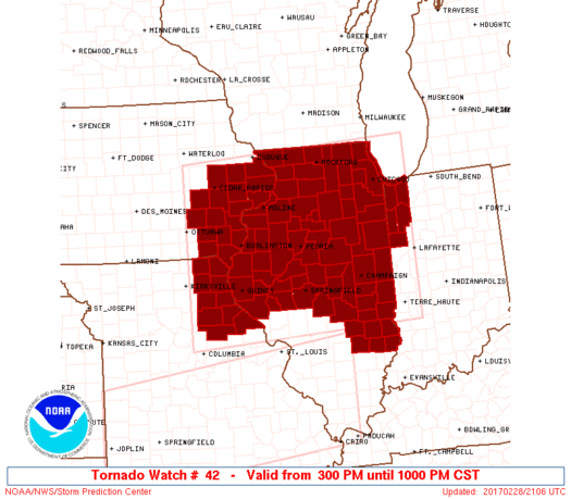
After being on the road for about an hour a mesoscale discussion and associated tornado watch was issued for our area.
We arrived in Mendota and got fuel and waited around for storms to initiate.
About an hour later a storm in Iowa to our NW went warned and looked to be a line of supercells behind it pegged to move across I-88.
At the same time storms had fired to the southwest of us as well so now we were faced with a grueling decision, go north to warned storms or drop south for forming storms.
The storms to the south looked a little ragged and linear at the time, while a storm to the north went tornado warned and every cell behind it had the same "tornadic signature" look to it, so the decision was made to make the dash back north to highway 30 and then head west to storms.
The drive seemed like it took forever once we got on highway 30, but our storm ha maintained its tornado warning and we were on a dead approach to it.
after getting west a ways the sky had cleared enough for us to see the cumulus tower and sun peaking out, a truly beautiful sight to see in itself!
We continued the journey west and a quick peak at radar revealed storms to the south had very dangerous looks to them and we knew we may regret going north.
At this point there was no turning back now though as our storm had just been tornado warned again and 2 areas of distinct rotation headed directly for us.
We turned north on a side road just outside Sterling, Illinois to see some beautiful supercell structure crossing the road ahead of us along I-88.
After realizing the day was over we stopped to watch the shelf move away and met up with a fellow chaser from Wisconsin, Dan Rupnow who had also chose to come north.
After talking for about 30 minutes we all decided it was time to call it a day.
The trip home was a short drive, but there we were, in February out chasing again.
Unfortunately a few lives were lost in this storm system as well as a many homes damaged and destroyed, our thoughts and prayers are with them.
Be sure to follow me on Twitter/Instagram @TomPurdyWI
or on facebook at @WisconsinWeatherPhotography


No comments:
Post a Comment