Sunday, December 6, 2015
April 9th, 2015 The day that I wasn't ready for.
Like so many storm chasers I look forward to the chase days, the wording of "A few strong tornadoes possible" this is what I love to do, this is my passion. Also like so many others I knew a time would come when I would see things that I didn't want to see.
The morning of April 9th was no different than any other chase other than the fact that our target was within 50 miles from home, virtually in our back yard. As a chaser you are excited, as a resident of the area you have a few extra nerves going.
When we left Janesville that early afternoon we knew there was a chance of seeing a tornado or 2, never did I imagine we were a few hours away from seeing the most violent tornado of 2015 in the U.S. The conditions were coming together very nicely! As the day progressed I began to wonder if we would see any good storms as they kept dying from being choked off all instability. As it would happen a storm would form about an hour before daylight would fade into the early Spring air and darkness would set upon us. Driving through large hail shortly after was the highlight of my day at the moment, the sound of baseball sized chunks of ice thumping against the roof of the car was music to my ears.
When the tornado warning was broadcast with the words "large and dangerous & particularly dangerous situation" your heart skips a few beats. I remember the sight of this monster and watching it spin and rip trees and earth up and being excited about this.
Soon we would drive through a few small communities, always wondering if it was in the path of this monster and was our chase over to start search and rescue. Fortunately none of the small towns were touched to that point.
We had pulled over to watch the tornado, still large, fade into the darkness. An eery roar was all you could hear, followed by sirens from emergency crews responding to anyone that did need aid.
While stopped along the road all I could smell was this distinct smell of earth, like you had just been working in your garden all day.
As we sat and watched the tornado disappear, residents had begun emerging from their homes and driving around the area checking on friends and loved ones. As we sat there trying to come down from the high of what we had just seen, a couple teenagers pulled up in a truck very excited as the tornado had come within a 1/4 mile of their home. As we talked a little one of them looked at the lot about 200 yards across the field and said "Hey that was so and so house" Looking over my heart immediately sunk deep into my stomach, what was once a house was simply reduced to a concrete slab. I remember calling my dad and being able to emotionally muster up the phrase "If anyone was in that house they are dead" Fortunately we later learned they were not home at the time.
The short drive home was quiet for the most part as we learned of severe damage and at least 1 death in Fairdale. The next morning I returned to the area for a few interviews and was just in awe of the damage. Less than 24 hours before this was a quiet little bedroom community that was now literally wiped off the map. While I was there a press conference was being conducted to announce a second confirmed fatality, something I always dreaded hearing or seeing.
When I left that afternoon I felt sick, how could something I love so much hurt so many people and me be ok with it? I took the long way home that afternoon and realized just how important life really is and how quick it can change.
In the weeks following I made a few return trips to volunteer and had the opportunity to meet people affected and hear their stores of that evening, more importantly I was treated like I belonged there, they welcomed me with open arms and offered me pie and coffee and donuts, etc. Some even found ways to joke about how they got closer than I was or how they got better video.
I knew storm chasing that I would eventually see some pretty big damage, never did I think I would see something so violent do so much horrific damage and never did I think I would be so mentally unprepared when the time came.
To the people of northern Illinois, first responders, meteorologists, volunteers....You are all amazing people and did one amazing job that night!
Friday, June 26, 2015
Coal City Tornado: A Survivors Story
![]() |
| Courtesy of Shawn McLey |
Coal City, Illinois is a small community of about 5,500 people that sits about 60 miles south of Chicago in Will and Grundy counties. A town that is not unfamiliar with tornadoes, on November 17th 2013 an EF-2 tornado ripped through part of town leaving many residents to rebuild.
Monday June 22nd started out as a normal day for Shawn McLey, his wife, and their 3 dogs. A summer rainstorm had came through the area that morning followed by a few peaks of sunshine and clouds. A chance of severe thunderstorms was in the forecast later that afternoon. Shawn and his wife went about their day, little did they know 90 miles away a storm would form that would change their lives forever. Around 3:30 pm a tornado watch was issued for most of north central and northwest Illinois. Around 7:00 pm a tornadic thunderstorm was taking shape Near Amboy, Illinois some 90 miles away and heading towards the small town of Coal City.
Meanwhile storm chaser Adam Lucio had already documented a couple tornadoes from this storm and was traveling along Interstate 80 trying to keep up with the storm. "I thought I was gonna die when the storm crossed over me on I-80" Lucio said. "I have never seen whiteout rain like that before, that thing was a monster"
At 9:06 pm a tornado warning was issued for Grundy county Illinois. As this tornadic storm was bearing down on the area, Shawn stated "I heard the sirens go off once" Around 9:30pm "The sirens went off a second time and my phone went off and we had about 3 minutes to take cover" I asked Shawn if he owned a weather radio to which he stated he did not. "We didn't have time to get into our crawl space, we just ran into the bathroom and huddled down. I can't get the sound of stuff hitting our house out of my head, the sound and the pressure was so intense" The tornado had now passed and Shawn, his wife and 3 dogs had all survived the tornado. A night they will not soon forget.
Reflecting back to that night and everything that had happened Shawn emotionally stated "People need to realize that when a warning is issued you better take it seriously because I could have been one of the people that died that night".
In closing what was a tragic day could have been much worse. 0 deaths were reported from 9 confirmed tornadoes across northern Illinois, a reflection of the amazing job the National Weather Service in Chicago truly does. People of northern Illinois are dealing with a lot this year, but they should also all be proud of the resilience they have shown this year.
A big thank you to Storm Chaser Adam Lucio and Shawn McLey for agreeing to do this with me.
This story is a true testament of how invaluable weather radios really are and maybe it is time as a community to require them in every home.
Be sure to check out Adam Lucio's page and the NWS Chicago for more great weather information!
Be sure to Check out my page also
Saturday, April 11, 2015
Ashton/Fairdale/Rochelle Illinois Tornado 4-9-2015
Thursday April 9th was a day that was on our radar for quite a few days prior, a low pressure system ejecting out of the plains that was forecasted to deepen along with an associate warm front and strong moisture was the basis for a possible severe weather setup. As early as 4 days prior the Storm Prediction center had outlined the area for possible severe weather as well as long as the atmosphere could recover from overnight convection and instability could build in.
The night before 2 things really stuck out while looking at models, one showed a decent area of clearing that would allow the instability to build and the other is a composite models that blends certain dynamics to give us a "significant tornado index" which had a bullseye over northern Illinois. The morning of an enhanced risk with a 10% tornado probability was given with the mention of possibly a strong tornado or 2.
Our starting point was The Mt Carroll area, a decent road network with options in all 4 directions if need be. While traveling south we encountered the warm front as the windows fogged and you could see the temp gauge jump a good 10 degrees in a matter of seconds. We traveled down I88 and decided to get off on US 30 and set up in Morrison incase we had to cross the river. The 1st tornado watch of the day was issued followed by a second 50 minutes later covering all of northern Illinois into southern Wisconsin.
The night before 2 things really stuck out while looking at models, one showed a decent area of clearing that would allow the instability to build and the other is a composite models that blends certain dynamics to give us a "significant tornado index" which had a bullseye over northern Illinois. The morning of an enhanced risk with a 10% tornado probability was given with the mention of possibly a strong tornado or 2.
Our starting point was The Mt Carroll area, a decent road network with options in all 4 directions if need be. While traveling south we encountered the warm front as the windows fogged and you could see the temp gauge jump a good 10 degrees in a matter of seconds. We traveled down I88 and decided to get off on US 30 and set up in Morrison incase we had to cross the river. The 1st tornado watch of the day was issued followed by a second 50 minutes later covering all of northern Illinois into southern Wisconsin.
One by one it would seem storms would initiate and then quickly die. This seemed to be as rain cooled air was sucking all the instability out of these storms so they were just unable to maintain.
Meanwhile in eastern Iowa along the cold front a few cells had seemed to tap into some better instability and maintain there supercell charachteristics After watching the cell for awhile and nothing good happening in our current target area we made the decision to cross the river into Iowa and go after this cell. After the 20 minute drive to the Mississippi river and crossing into Iowa, we quickly realized that this was probably not the best move for us for 2 reasons. 1. There are very limited river crossings back into Illinois to stay with the storm and 2. We learned over a few events to stick with the original plan.
We crossed the Mississippi river back into Illinois and decided to go back to the Morrison area and wait for the storm to cross the river to us. After what seemed like an eternity the storm was finally approaching the river and had a decent hook and rotation on it according to radar. We got into position north of Morrison and awaited the arrival of the now tornado warned storm.
After a few minutes and seeing some lightning the storm arrived and had almost no structure and we quickly realized that if a tornado was in there it would surely be rain wrapped and in our best interest to get a little further east and try to gain some better visibility of the base. As we retreated east the storm lost most of its rotation and was now looking to be gusting out. As we were contemplating our next move a cell had quickly formed to our southwest and would become severe warned in a matter of minutes.
Over time I have learned that certain storms have a certain "shape" to them and this one definitely seemed to fit the build. We decided to abandon the storm to our west and make a beeline east to try and catch up with this cell as it was now starting to rotate and look very healthy.
We passed through Oregon, Illinois and across the Rock river on route 64 where the tornado sirens were echoing across the whole city. We met up with the cell that was now tornado warned and had a distinct supercell shape with complete with a hook and strong rotation. We were positioned NW of the storm so a decision needed to be made whether to attempt a dangerous core punch or allow the storm to move a little further northeast and get behind it.
After proceeding a little further east into the core of the storm we were met with some baseball sized hail that was pounding the car and in danger of shattering the windshield so we decided to pull over and go with plan B.
After being pelted with hail for several minutes the tornado emerged from behind the wall of rain and hail and much to our surprise was a rather large "wedge" tornado. 

We procceded to follow and stair step the tornado as long as we could before getting cut off by law enforcement and damage along the way. We stopped on the side of the road to snap some ore pictures and the tornado evaded us and disappeared into the dark skies to our northeast. A smell of pine and earth filled the air along with an eery silence. Several law enforcement were just across the field from us and we would soon learn that bare spot we were seeing was once a house that was now reduced to a slab of concrete. Luckily they were not home at the time. After the tornado had disappeared we were greeted with an ominous shelf that would be the end of our day.
Unfortunately 2 people lose their lives in Fairdale as well as many houses and structures demolished along the way. I made a return trip to Fairdale the next day and was completely taken aback by what the power of nature is truly capable of.
Our thoughts and prayers are with everyone affected by this tragedy.
Like us on Facebook. https://www.facebook.com/WisconsinWeatherPhotography
Wednesday, May 21, 2014
One Hail of a Day 5-20-2014
Tuesday May 20th was a rather questionable severe weather day, with a weak cold front dropping southeast and a pretty moist air mass forecasted there was a chance at a few severe thunderstorms to pop up, but the question remained if a shortwave would show up in time to trigger any storms before sunset. A slight risk was issued for far southern Wisconsin and northern Illinois for the potential of some pretty large hail and possibly a few tornadoes.
Being it as local as it was there was no way to pass up chasing it, at worst we would see lightning at sunset. The plan was for Jason and I to meet up after I got done with work at 4pm, we would also be joined by Mike Abernethy. Our initial idea was to just drift west and wait for storms to pop up along the front and go from there, a few models did hint at storms popping up further to the south but where it was gonna happen was the question. a little before 4 a severe thunderstorm watch was issued for the immediate area and it looked like storms would be soon to follow.
Much to my frustration storms did indeed start to form south of my original thinking and we would now need to plan a different route. We set sail on I-39 south with the intention of heading west on highway 20 in northern Illinois to reach a line of supercells that had rapidly formed from around Mt Carroll Illinois back to Dubuque. After making our turn west we got caught in standstill traffic and had to detour south to get out of the traffic and then make our way back west. While having a little bit of difficulty getting on a decent road back west, it became apparent that these supercells were moving very slow and not showing much sign of converging into a line as we also once thought. While making our way west a little rain shower popped up with lightning just to our west, in all honestly it looked like a very disorganized blob for a couple scans. While watching the updraft from this storm tighten right up it became apparent that this little cell was trying, on the very next scan it was a full blown supercell that would quickly go warned for large hail, chase on!
We had to make a short little trip south through the core of this storm to get to the south end and into better viewing position, while doing this we missed the hail core by seconds but a we would soon see some large hail covering the ground and some pretty extensive tree damage from the hail. We stopped for a few pictures of some of the hail stones and found most of them to be ping pong size to golf ball size.
After several minutes had passes the storm had moved well east of us and we decided to let it go as it was about to converge with another cell and was starting to weaken, but the structure on the backside filled with constant flashes of lightning was a beautiful sight to watch.
As this storm passed us we now had to make a decision, call it a chase and head home or wait out several more storms in Iowa slowly heading in our direction. After some thought we decided to keep after it. we slowly started to work our way back west to get into position for a beautiful supercell coming out of Iowa and into northern Illinois. With sunset quickly approaching though we were forces with the decision of just how far west we wanted to go, chasing in northwest Illinois is challenging enough, let alone doing it in the dark. The best possible spot looked to be just west of Byron, we could cross the river and get back out into open country and await the arrival of the next round. While making our way west we were treated to another storm that quickly went severe but weakened just as quick. It did although have some nice lightning with it for us to view with a beautiful colored sky in the backdrop.
After this storm had died and the sun quickly set, we now played the waiting game. After about 45 minutes, a fight with a foggy river valley and a difficult time finding a shootable spot we settled on an area overlooking the western horizon, the only problem is our once beautiful storm was weakening and was now not even warned. After another 15 minutes or so the storm once again rapidly intensified and was heading right at us. We got the tripods and cameras set up and anxiously awaited our chance at some lightning. In just a matter of a few minutes the storm had went from a weakening stage back to a full blow severe storm that quickly went severe warned again, this time for more golf ball size hail. After watching the flashes and anvil crawlers across the sky for several minutes, we were treated to a lightning barrage like I have never seen before, there was non stop strikes for 5 minutes, one right after another.
Being it as local as it was there was no way to pass up chasing it, at worst we would see lightning at sunset. The plan was for Jason and I to meet up after I got done with work at 4pm, we would also be joined by Mike Abernethy. Our initial idea was to just drift west and wait for storms to pop up along the front and go from there, a few models did hint at storms popping up further to the south but where it was gonna happen was the question. a little before 4 a severe thunderstorm watch was issued for the immediate area and it looked like storms would be soon to follow.
Much to my frustration storms did indeed start to form south of my original thinking and we would now need to plan a different route. We set sail on I-39 south with the intention of heading west on highway 20 in northern Illinois to reach a line of supercells that had rapidly formed from around Mt Carroll Illinois back to Dubuque. After making our turn west we got caught in standstill traffic and had to detour south to get out of the traffic and then make our way back west. While having a little bit of difficulty getting on a decent road back west, it became apparent that these supercells were moving very slow and not showing much sign of converging into a line as we also once thought. While making our way west a little rain shower popped up with lightning just to our west, in all honestly it looked like a very disorganized blob for a couple scans. While watching the updraft from this storm tighten right up it became apparent that this little cell was trying, on the very next scan it was a full blown supercell that would quickly go warned for large hail, chase on!
We had to make a short little trip south through the core of this storm to get to the south end and into better viewing position, while doing this we missed the hail core by seconds but a we would soon see some large hail covering the ground and some pretty extensive tree damage from the hail. We stopped for a few pictures of some of the hail stones and found most of them to be ping pong size to golf ball size.
After several minutes had passes the storm had moved well east of us and we decided to let it go as it was about to converge with another cell and was starting to weaken, but the structure on the backside filled with constant flashes of lightning was a beautiful sight to watch.
As this storm passed us we now had to make a decision, call it a chase and head home or wait out several more storms in Iowa slowly heading in our direction. After some thought we decided to keep after it. we slowly started to work our way back west to get into position for a beautiful supercell coming out of Iowa and into northern Illinois. With sunset quickly approaching though we were forces with the decision of just how far west we wanted to go, chasing in northwest Illinois is challenging enough, let alone doing it in the dark. The best possible spot looked to be just west of Byron, we could cross the river and get back out into open country and await the arrival of the next round. While making our way west we were treated to another storm that quickly went severe but weakened just as quick. It did although have some nice lightning with it for us to view with a beautiful colored sky in the backdrop.
After this storm had died and the sun quickly set, we now played the waiting game. After about 45 minutes, a fight with a foggy river valley and a difficult time finding a shootable spot we settled on an area overlooking the western horizon, the only problem is our once beautiful storm was weakening and was now not even warned. After another 15 minutes or so the storm once again rapidly intensified and was heading right at us. We got the tripods and cameras set up and anxiously awaited our chance at some lightning. In just a matter of a few minutes the storm had went from a weakening stage back to a full blow severe storm that quickly went severe warned again, this time for more golf ball size hail. After watching the flashes and anvil crawlers across the sky for several minutes, we were treated to a lightning barrage like I have never seen before, there was non stop strikes for 5 minutes, one right after another.
After this round we called it a chase, the trip home was filled with flashes of lightning all around and stories of past chases as well as some amazing stories of Mikes medical adventures. A truly all around awesome chase!
Mike Abernethy is a physician for UW Med Flight in Madison, like them on Facebook for some amazing stories and pictures from the sky https://www.facebook.com/uwmedflight
Also be sure to like us on Facebook https://www.facebook.com/WisconsinWeatherPhotography
Thank you all for taking the time to read, until next time :)
Thursday, May 1, 2014
Western Illinois Squeeze Play
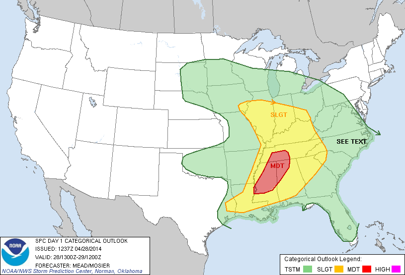
Monday 4-28 brought us to western Illinois where the "squeeze play" term is one I like to use for a setup like this, you drive about 20 miles south of the warm front and hope like hell the storms can produce a tornado before it crosses that boundary. The setup looked very promising that morning, with a warm front draped from about Galesburg, Illinois to the southeast and strong low pressure in far eastern Nebraska with an approaching cold front.
That morning everything seemed to be coming together nicely for a few supercells that could produce tornadoes, with a peak to visible satellite in that area, skies seemed to be clearing and destabilizing nicely After reviewing a few things we set our target to Macomb, Ill. When we hit the road the temps were in the high 40s in southern Wisconsin, as we made our way to the Quad cities and south on I-74 the temperature slowly began to rise and skies were clearing. When we finally crossed the warm front the temp shot up to near 75F and the dewpoints into the low 60s. After looking at radar and satellite for a bit, it looked like the arc of cumulus would ignite storms in Iowa across the river, with very limited river crossings we did not want to take that risk so we decided to play it out in hopes storms would fire on our side of the river. After watching several towers trying to go up and not surviving long, one to our southwest seemed to stay pretty persistent and was now showing some decent amounts of lightning on radar so we decided to give this cell a shot. We met with this cell on a rural highway west of Macomb and was surprised at the constant rumble of thunder it had with it, while trying to get into a better position to view, we chose a road that was, well absolutely terrible! (see video)
After quickly making our way back to the main road we caught back up with this cell that had one of the weirdest yellow looking cores I have ever seen along with some beautiful intercloud lightning.
While watching this in amazement for awhile, the storm started to slowly drift off to our north so we had to reposition and quickly catch back up to it on rural gravel roads. After catching back up to the storm it seemed to be taking on supercell type characteristics and looked like it was developing a wall cloud with a classic clear slot punching in from the right side.
After several minutes of trying to organize into a nice supercell, the storm was quickly merging with other storms and becoming more outflow type storms with bowing segments, a sign that the threat for tornadoes was quickly reducing. We decided to abandon this cell after awhile and position ourselves in front of a little bowing segment that looked very beefy on radar. After finding a gravel road with a great view the storm was coming into view on the horizon and a beautiful shelf was emerging.
The green core and beautiful structure made for a few beautiful pictures. After getting back ahead of this cell on the highway it was rotating like a top on the leading edge right behind us but would never quite survive the battle with crossing the boundary into stable air. We soon decided to call it a day and head north towards home where we enjoyed a great lightning display to keep us entertained for awhile. Although no tornadoes this tie, we did have several laughs and see some great stuff. Until next time, thank you for coming along for the journey :)
Like us on Facebook: https://www.facebook.com/WisconsinWeatherPhotography
Wednesday, April 30, 2014
Outrunning the Iowa Bow
Sunday April 27th was a day we had been eyeing for a few days as a possible chase day. The setup was classic for spring tie severe weather, a strong low and associated warm front moving north, as a strong dryline was moving east over all the warm, unstable air. The original plan was to head to Kansas and chase Saturday and pick up the chase on Sunday in Iowa/Missouri. After much debate the models just did not seem to show the CAP breaking much on Saturday in Kansas so waiting to see how Sunday would play out was next on the list. Models did show the warm front sneaking into southern Iowa Sunday so the decision was made to go for it.
With the models indicating early storms we decided to set sail around 6am with the target being Bethany Missouri. The one very large drawback was would early morning convection be enough to ruin the setup and force the warm front south and would storm mode be discrete supercells, a chance you sometimes have to take. As we made the 7 hour trek across Illinois and Iowa the temps north of the front were lingering in the 50s, we made it to Des Moines and started south and crossed the front where temps rose into the 70s and and dewpoints into the 60s. The only problem was morning convection was refiring and the chance for discrete supercells was dropping pretty fast.
Pretty soon a line had started to form and we soon knew this was our play of the day. As the line grew a few spuds began to pop up ahead of the main line and drop some big time lightning so we decided to try our luck at a few lightning pictures before the chase started.
After shooting lightning for awhile the line was starting to intensify so we decided to move a little east and let it get going a little more. As we got our 1st glimpse of the shelf coming over the hill it looked pretty neat on the base but nothing spectacular other than that.
The storm itself was moving rather slowly so we decided to keep racing east and try to stay out ahead of it as long as we could. Several times we stopped and would see the shelf approaching us with not much improvement in structure so we would again continue east and see what happens. When we approached Monroe county, IA we found a spot with a great view and decided to go ahead and let it overtake us before continuing on our way, the shelf on it now was really nice looking and the underside of it was spectacular!
While sitting here in this spot after the shelf had overtaken us we decided to film the winds in it as it was now warned for winds of 70mph, we sat and watched as a few large limbs flew off trees and tore a few shingles off of nearby roofs. We then continued to move east and were overtaken by some of the strongest winds I can ever remember encountering, The winds were so intense at one point we lost all visibility and had to pull over and let it pass us up. After the most intense part of the line had passed we continued on our way and crossed the Mississippi river back into Illinois where we caught up to the storm one more time and got one last glimpse of the shelf over a wind farm before dark.
All in all it was a fun day but not what we were hoping for when the day had started. Being able to keep up with a squall line that long was pretty awesome though. Below is the video of the shelf and intense wind as it crossed us in Monroe county Iowa. Thank you all for taking the time to read :)
Like us on Facebook: https://www.facebook.com/WisconsinWeatherPhotography
Friday, April 4, 2014
A Special Chase in an Unexpected Place 3-30-14
On this particular Sunday I was in California for the weekend visiting my brother who will soon be deploying. As a series of weather systems came in the Pacific Northwest, a threat for isolated severe weather was a possibility in the Sacramento valley area. The previous day a few tornado warned cells did pop up about 40 miles to the north of our location, one in which produced an EF-0 tornado. While taking a peak at radar early Sunday afternoon, a cell to our west caught my eye as having a certain "shape" to it, a shape that you often see a storm take on when it its a mature/strong storm. After watching this storm on radar for a little bit my brother and I decided to give a local chase a go.
The route to get to the storm took us through Yuba City, now most of you know me know that I am from Wisconsin and would not wish California drivers on anyone, not to mention the over abundance of stop lights. As we finally made our way through town we gout our 1st decent view of the storm, quite a beautiful cell to my surprise.
After finally reaching the storm near Sutter, we got a view of the storm and Sutter Butte mountain range together, one of the most beautiful sights I could ever imagine.
We sat and watched the storm for awhile and just taking in the beauty of it when a wall cloud with some decent rotation did start to form along the rear flank of the storm.
After watching this for a little while and hoping it would produce a surprise California tornado, the storm was quickly halted by more stable air over the mountains. As the storm began to die it did leave a parting shot of beautiful lightning over the green fields.
Normally a chase like this would not be anything special, but it marked a few firsts for me. My 1st chase of 2014, my 1st California chase and most importantly my 1st chance to chase with my brother, that alone made it something very special to me and this will forever be one of my favorite chases.
The route to get to the storm took us through Yuba City, now most of you know me know that I am from Wisconsin and would not wish California drivers on anyone, not to mention the over abundance of stop lights. As we finally made our way through town we gout our 1st decent view of the storm, quite a beautiful cell to my surprise.
After finally reaching the storm near Sutter, we got a view of the storm and Sutter Butte mountain range together, one of the most beautiful sights I could ever imagine.
We sat and watched the storm for awhile and just taking in the beauty of it when a wall cloud with some decent rotation did start to form along the rear flank of the storm.
After watching this for a little while and hoping it would produce a surprise California tornado, the storm was quickly halted by more stable air over the mountains. As the storm began to die it did leave a parting shot of beautiful lightning over the green fields.
Normally a chase like this would not be anything special, but it marked a few firsts for me. My 1st chase of 2014, my 1st California chase and most importantly my 1st chance to chase with my brother, that alone made it something very special to me and this will forever be one of my favorite chases.
Subscribe to:
Posts (Atom)